

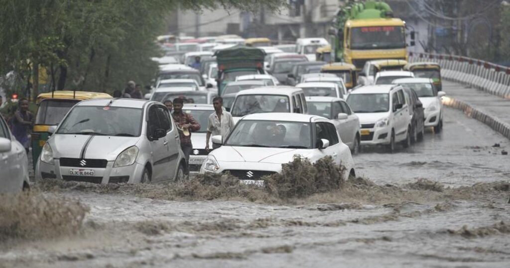
On Saturday, 126.1mm of rain was recorded in the Capital, the most rain for a July day in 21 years. This torrential downpour caused havoc in the streets of the Capital and prompted the India Meteorological Department to issue a red alert in the late afternoon.
The Minto Bridge, the Pragati Maidan tunnel, and the Kalindi Kunj underpass were among the major underpasses and low-lying stretches that were flooded, according to a situation alert issued by the Delhi Traffic Police at 3:30 p.m. There was waterlogging at 56 locations that disrupted traffic, fallen trees that partially or completely blocked seven stretches, and major underpasses and low-lying stretches.
According to IMD authorities, the interaction between monsoon winds and a western disturbance caused Saturday’s rain, which was categorised as “very heavy,” to fall throughout most of north-western India.
“Since 133.4 mm were reported on July 10, 2003, this is the greatest single day rainfall in Safdarjung in July when a 24-hour period was taken into account. It is probable that even this number may be surpassed by 8:30 am on Sunday morning with the rain expected on Saturday starting in just nine hours. More rain is expected in the early hours of Sunday and overnight, according to the IMD’s 24-hour period, which runs from 8:30 am to 8:30 am the following day.
The havoc that the rain caused in the Capital is a disturbing reminder of how unprepared the city is for the monsoon. The deficiency is especially glaring since it occurs when authorities and institutions are working to prepare Delhi for the G20 conference scheduled for September. Only since it being the weekend, the situation for civilians did not deteriorate on Saturday. To support its goal of becoming a world-class metropolis, Delhi has to maintain its municipal infrastructure.
3.4mm of rain fell in a 24-hour period at Safdarjung, a neighbourhood that serves as a weather gauge for Delhi, up until 8:30 on Saturday morning. However, it got 126.1mm of rain during the course of the next nine hours. The Ridge Station in north Delhi had the greatest rain during these nine hours, with 128mm recorded there, compared to 118.2mm at Lodhi Road. Heavy rain was reported at the stations at Delhi University (86mm), Pitampura (83mm), and Pusa (67.5mm), while moderate rainfall totals of 29.6mm at Ayanagar and 17.8mm at Palam were also recorded during this time.
The next 24 to 36 hours are expected to see a western disturbance move extremely slowly. With an integrated cyclonic circulation over southwest Rajasthan, the monsoon trough is moving south of where it normally is, up to lower tropospheric levels, according to the IMD statement on Saturday.
According to officials, it will likely continue to rain at the start of next week. There’s a possibility that Sunday brought some light rain to Delhi. On Monday and Tuesday, there is a chance of light to moderate rain once again, and the monsoon trough is expected to stay near to Delhi NCR, the source noted.
Only one day like this is often recorded each year in the capital, making very severe rain periods quite uncommon. The last time this happened was on July 1, 2022, when 117.2mm of rain fell. Only two further “heavy rain” days were noted in the same year.
Private forecasts said that northwest India is presently exhibiting symptoms of typical monsoon rain recording, at least for the month of July. Mahesh Palawat, vice-president (meteorology and climate change), Skymet Weather, said that “most parts of northwest India have already reached the normal rainfall mark for the month, and the forecast shows that similar intensity rain is likely to continue for another two to three days.”
The long-period average for July, 209.7mm, is set to be exceeded by the end of the month in the Capital, where the first eight days of the month had produced 164.1mm of rain. There’s little doubt that this has been the case in recent years, as shown by the city’s above-average rainfall totals in 2022 (286.3mm), 2021 (507.1mm), and 2020 (236.9mm).
The Saturday high in Delhi was 28.7 degrees Celsius, which is eight degrees below average. Three degrees below average, the lowest temperature was 25 degrees Celsius. In contrast, the highest and lowest temperatures on Friday were 35 and 26.7 degrees Celsius, respectively. According to forecasts, Sunday’s highest temperature will be about 30 degrees, while the low will be around 24 degrees.