


As the river continued to flow over the “evacuation mark” at 206 metres, thousands of people living on the Yamuna floodplains moved to roadways along the river. The Central Water Commission warned that the water level may reach 207 metres by 3 am on Wednesday.
Officially, the “warning level” is defined as a water level of 204.5 metres, the “danger level” as a level of 205.33 metres, and the “evacuation level” as a level of 206 metres.
On Tuesday morning, when hundreds of people began constructing improvised shelters, thin bamboo sticks and thick plastic sheets were scattered on the roadside throughout the stretch from Noida Link Road to Mayur Vihar, DND Flyway, nursery pushta, and across the length of NH24 up to close to Pragati Maidan.
The river increased gradually from 206.08 metres at 1am to 206.69 metres at 7pm as a result of 2.1 to 3.5 lakh cusecs of water being released from the Hathnikund barrage, close to Yamuna Nagar in Haryana, per hour.
Gopal Rai, the minister of development, stated that authorities have been told to provide the evacuees all of the necessities. “The government established about 2,700 relief centers/tents for relief and rescue, which can accommodate about 27,000 people,” he stated. In areas like Geeta Colony, Madanpur Khadar, Garhi Mandu, Palla, Hiranki, Yamuna Bazar, and Mayur Vihar, the government has established shelters.
In addition to the government-established shelters, hundreds of people have begun constructing tents beside the road and bringing their families to the locations.
“Thin bamboo sticks are needed since they bend readily, and thick plastic sheets are needed so that the structure will withstand the next days’ worth of rain and wind. This is an annual drill, and we are well prepared. Every year, we had to leave for roughly a month. We alternately maintain watch through the night after the flood warnings are issued to determine when the water levels will increase, according to Gendan Lal, a vegetable grower who lives with his family close to the floodplains.He has pitched his camp close to the boundary between Delhi and Noida.
In a tent next to the Akshardham temple, Mala (who goes by one name) was drying recently harvested red chiles over a single bedsheet. “Since we had children, we shifted early to avoid waiting until the last minute. By 7am, my boys had the tent pitched. The chilies need to dry rapidly since they became wet as the water level rose; else, the whole batch would deteriorate.
Farmer Raj Ram was one of several families who had set up camps on the Barapullah expansion, which is still under construction and is close to Mayur Vihar. He said that the alarm was sent out by the administration too late. “When the water level rose in the middle of the night, we had to hurry since the official announcement began late. We constructed our camps by afternoon. Every monsoon for the previous several years, we have done this. Here, food and water are not being supplied to us, said Ram.
An evacuation notice was issued two days ago, according to East Delhi District Magistrate Anil Banka, and residents started moving Monday. “According to projections from the Central Water Commission, the water level was supposed to surpass 206 metres by Tuesday, but it did so a day earlier. So far, at least 7,350 individuals have been evacuated. Depending on how high the river level rises, more individuals may be relocated. Additionally, we have provisions for long-term shelters,” he said.
According to Saurabh Bharadwaj, minister of irrigation and flood control in Delhi, two large halls in government buildings have been converted into rooms for evacuees in the north district. In addition, 170 tents have been erected in Shahadra, 280 in the north-east district, 150 in the central district, and 384 in the south-east district. The east district, which has been the worst-affected section, has the most units put up (1,713).
Bhardwaj, who examined the emergency measures in the vicinity of Akshardham in east Delhi, said that Haryana is releasing around 3.69 lakh cusecs of water. “Due to heavy rain in Himachal Pradesh, a lot of water has also been spilled from Solan and Shimla into the river. This is also anticipated to get to Delhi through Hathnikund, he added.
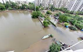
The Yamuna river runs through the Capital for about 22 kilometres, but through time, inhabitants have encroached on its floodplains. According to a representative of the irrigation and flood control department, the boat club and the flood and irrigation department have stored around 50 boats at the ready for any emergency. I&FC has identified 17 vulnerable spots, including the Delhi gate, Metcalf house, Tonga stand area, drains 12 and 12A, and Vijay Ghat. Together with the civil government, Delhi Police on Tuesday saved the lives of 19 people—including 10 children and four women—who were trapped in the fields near the Yamuna Khadar because of the heavy flooding.
On the floodplains, migrant workers have erected hutments, and the destitute have taken refuge beneath the bridges. Slums and concrete homes have sprung up close to the floodplains in locations like Yamuna Bazaar. It is believed that around 35,000 people reside entirely inside flood plains.
In the meanwhile, the Delhi BJP said that the party had established relief camps at eight locations, including Yamuna Bazar and Old Delhi, which were opened by Virendra Sachdeva, the leader of the Delhi party.
Although these warnings are now a yearly occurrence, the city’s maximum flood level was recorded in September 1978, when the Yamuna reached a height of 207.49 metres. According to a senior government official, the Najafgarh drainage system saw excessive water levels on many occasions in 1977, 1978, 1988, 2011, and 2013. “During this period, a heightened level of vigilance is maintained on river embankment when large volumes of released in the river upstream and heavy rainfall in the catchment area can lead to river attacking its embankments and additional measures need to be taken to check any abnormal erosion,” official added.


